- News
- Aeronautic Laws
- Chronology/Events
- Aviation Pioneers
- Aviation Pioneers
- John Rodgers
- Emory Bronte
- Lt. Ben Cassiday
- Major Harold Clark
- Capt. John Curry
- Amelia Earhart
- Charles Fern
- Lt. Harold Geiger
- Arthur C. Goebel
- Dick Grace
- Tom Gunn
- Lt. Albert F. Hegenberger
- Martin Jensen
- Sir Charles Kingsford-Smith
- Lt. Lester Maitland
- J.C. “Bud” Mars
- Didier Masson
- Emil L. Melville
- Gus Schaefer & Burton Dryer
- Ernest Smith
- W. Ben Stoddard
- Charles Stoffer
- Elbert and Malcolm Tuttle
- Joseph Lawrence Van Tassell
- Clarence H. Walker
- Marguerite Gambo Woods
- Sen Yet Young
- Airfields & Airports
- Airfields & Airports
- Oahu
- Oahu
- John Rodgers Airport
- Honolulu International Airport
- Honolulu International Airport Air Traffic Statistics
- Ala Moana Airport
- Ala Wai Heliport
- Barber’s Point
- Bellows Field
- Dillingham (Kawaihapai) Airfield
- Ford Island/Luke Field
- Haleiwa Field
- Hickam Field/Air Force Base
- Kalaeloa Airport
- Kaneohe Naval Air Station
- Kipapa Field
- Naval Air Station 29 (Honolulu)
- Wheeler Field
- Hawaii
- Hawaii
- The Beginning of Aviation on the Big Island
- General Lyman Field/Hilo International Airport
- Ka Lae/Kau Airport
- Kamuela Airport (Bordelon Field)
- Kona Airport at Kailua
- Kona International Airport at Keahole
- Morse Field (South Cape Airport)
- Naalehu Airport
- Paauilo Airport
- Upolu Airport
- Waimea-Kohala Airport
- Hawaii Airport District Managers
- Kauai
- Lanai
- Maui
- Maui
- The Beginning of Aviation on Maui
- Hamoa Airport (Old Hana Airport)
- Hana Airport
- Kaanapali Airstrip
- Kahului Airport
- Kapalua Airport (West Maui)
- Kula Airport
- Lahaina Airport
- Maalaea Airport
- Naval Air Station 27 (Kahului)
- Naval Air Station 30 (Puunene)
- Maui Airport (Puunene)
- Maui District Airport Managers
- Molokai
- Seaplane Anchorage
- Seaplane Anchorages
- French Frigate Shoals Seaplane Anchorage
- Pearl Harbor – Fleet Air Base Seaplane Anchorage
- Kaneohe Bay Seaplane Anchorage
- Kaunakakai Harbor Seaplane Anchorage
- Kamalo Harbor Seaplane Anchorage
- Lahaina Roads Seaplane Anchorage
- Kahului Harbor Seaplane Anchorage
- Hana Bay Seaplane Anchorage
- Kaumalapau Harbor Seaplane Anchorage
- Hanapepe Bay Seaplane Anchorage
- Nawiliwili Bay Seaplane Anchorage
- Hanamaulu Bay Seaplane Anchorage
- Hanalei Bay Seaplane Anchorage
- Kealakekua Bay Seaplane Anchorage
- Kawaihae Bay Seaplane Anchorage
- Kailua Bay Seaplane Anchorage
- Hilo Bay Seaplane Anchorage
- French Frigate Shoals
- Ceded Lands
- Major Air Incidents
- Airliners
- Pioneer Airlines
- Pioneer Airlines
- Inter-Island Airways/Hawaiian Airlines
- Pan American Airways
- Aloha Airlines
- Andrew Flying Service
- British Overseas Airways Corp
- Canadian Pacific Air Lines
- Continental Airlines
- EVA Air
- Gambo Flying Service
- Japan Air Lines
- Northwest Orient Airlines
- Omni
- Philippine Airlines
- Qantas
- Teal
- Trans International Airlines
- United Air Lines
- World Airways
- World War II
- World War II
- December 7, 1941
- December 7, 1941
- A Handful of Pilots
- Hickam Field December 7, 1941
- Attack at Bellows Field
- Brief Summary of December 7, 1941
- Cloak of Darkness
- George J. Gabik Memories
- Enterprise Air Group Report on December 7, 1941
- First to Fight
- Hickam Report December 8, 1941
- Highlights of December 7, 1941
- Hot Reception at Pearl Harbor
- One Sunny Day on Niihau
- Pearl Harbor’s Deadly Dozen
- Report of Enemy Activity December 7, 1941
- Roosevelt’s Day of Infamy, My Day of Hell
- Summary of the Attack, December 7, 1941
- The Story of Joseph I. Muratsuchi
- The True Story of Pearl Harbor
- Those Aging Ghosts of Pearl Harbor
- Three Hours of Hell
- Eye Witness Accounts of Bombing of Hickam AFB
- World War II Photo Gallery
- Military Aviation on Oahu, 1944
- Corps of Engineers WW II Pacific Operations
- Interview with Lt. George S. Welch
- Aviation Photos
- Publications
- Publications
- HNL – First 80 Years
- HNL – 80th Anniversary Brochure
- 25th Anniversary John Rodgers Terminal 1987
- Territorial Aeronautical Commission
- DOT Annual Reports
- DOT Annual Reports
- 1962-1963 DOT Annual Report
- 1964 DOT Annual Report
- 1965 DOT Annual Report
- 1966 DOT Annual Report
- 1967 DOT Annual Report
- 1968 DOT Annual Report
- 1969 DOT Annual Report
- 1970 DOT Annual Report
- 1971 DOT Annual Report
- 1972 DOT Annual Report
- 1973 DOT Annual Report
- 1974 DOT Annual Report
- 1975 DOT Annual Report
- 1976 DOT Annual Report
- 1977 DOT Annual Report
- 1978 & 1979 DOT Annual Report
- 1980 DOT Annual Report
- 1981 DOT Annual Report
- 1982 DOT Annual Report
- 1983 DOT Annual Report
- 1984 DOT Annual Report
- 1985 DOT Annual Report
- 1986 DOT Annual Report
- 1987 DOT Annual Report
- 1985 DOT Annual Report
- 1986 DOT Annual Report
- 1987 DOT Annual Report
- 1991 DOT Annual Report
- 1992 DOT Annual Report
- 1993 DOT Annual Report
- 1994 DOT Annual Report
- 1995 DOT Annual Report
- 1996 DOT Annual Report
- 1997 DOTAnnual Report
- 1998 DOT Annual Report
- 1999 DOT Annual Report
- 2000 DOT Annual Report
- 2001 DOT Annual Report
- 2002 DOT Annual Report
- 2003 DOT Annual Report
- 2004 DOT Annual Report
- 2005 DOT Annual Report
- 2006 DOT Annual Report
- 2007 DOT Annual Report
- Territory of Hawaii Superintendent of Public Works Reports
- Territory of Hawaii Superintendent of Public Works Reports
- 1932 TH Public Works Report
- 1933 TH Public Works Report
- 1934 TH Public Works Report
- 1935 TH Public Works Report
- 1936 TH Public Works Report
- 1937 TH Public Works Report
- 1938 TH Public Works Report
- 1939 TH Public Works Report
- 1940 TH Public Works Report
- 1941 TH Public Works Report
- 1943 TH Public Works Report
- 1946 TH Public Works Report
- 1947 TH Public Works Report
- 1948 TH Public Works Report
- 1950 TH Public Works Report
- 1951 TH Public Works Report
- 1952 TH Public Works Report
- 1953 TH Public Works Report
- 1954 TH Public Works Report
- 1955 TH Public Works Report
- 1956 TH Public Works Report
- 1957 TH Public Works Report
- 1958 TH Public Works Report
- Hawaii Aeronautics Commission
- Hawaii Aeronautics Commission
- HAC Annual Reports
- HAC Annual Reports
- 1948 Hawaii Aeronautics Commission Report
- 1949 Hawaii Aeronautics Commission Report
- 1950 Hawaii Aeronautics Commission Report
- 1951 Hawaii Aeronautics Commission Report
- 1952 Hawaii Aeronautics Commission Report
- 1953 Hawaii Aeronautics Commission Report
- 1954 Hawaii Aeronautics Commission Report
- 1955 Hawaii Aeronautics Commission Report
- 1956 Hawaii Aeronautics Commission Report
- 1957 Hawaii Aeronautics Commission Report
- 1958 Hawaii Aeronautics Commission Report
- 1959 Hawaii Aeronautics Commission Report
- 1960 Hawaii Aeronautics Commission Report
- HAC Minutes
- HAC Minutes
- HAC Minutes 1947
- HAC Minutes 1947
- HAC 1947-06-20.pdf
- HAC 1947-07-07.pdf
- HAC 1947-07-16.pdf
- HAC 1947-07-28.pdf
- HAC 1947-08-04.pdf
- HAC 1947-08-11.pdf
- HAC 1947-08-25.pdf
- HAC 1947-08-26.pdf
- HAC 1947-08-28.pdf
- HAC 1947-09-04.pdf
- HAC 1947-09-09.pdf
- HAC 1947-09-23.pdf
- HAC 1947-10-06.pdf
- HAC 1947-10-20.pdf
- HAC 1947-11-03.pdf
- HAC 1947-11-05.pdf
- HAC 1947-11-07.pdf
- HAC 1947-11-24.pdf
- HAC 1947-12-01.pdf
- HAC 1947-12-15.pdf
- HAC 1947-12-29.pdf
- HAC Minutes 1948
- HAC Minutes 1948
- HAC 1948-01-05.pdf
- HAC 1948-01-10.pdf
- HAC 1948-01-16.pdf
- HAC 1948-02-02.pdf
- HAC 1948-02-06.pdf
- HAC 1948-02-16.pdf
- HAC 1948-02-26.pdf
- HAC 1948-03-01.pdf
- HAC 1948-03-12.pdf
- HAC 1948-03-22.pdf
- HAC 1948-04-05.pdf
- HAC 1948-04-14.pdf
- HAC 1948-05-03.pdf
- HAC 1948-05-25.pdf
- HAC 1948-05-28.pdf
- HAC 1948-06-07.pdf
- HAC 1948-06-21.pdf
- HAC 1948-07-06.pdf
- HAC 1948-08-02.pdf
- HAC 1948-09-03.pdf
- HAC 1948-09-13.pdf
- HAC 1948-10-04.pdf
- HAC 1948-10-15.pdf
- HAC 1948-11-01.pdf
- HAC 1948-11-08.pdf
- HAC 1948-12-06.pdf
- HAC 1948-12-13.pdf
- HAC Minutes 1949
- HAC Minutes 1949
- HAC 1949-01-03.pdf
- HAC 1949-01-17.pdf
- HAC 1949-01-24.pdf
- HAC 1949-02-01.pdf
- HAC 1949-02-07.pdf
- HAC 1949-02-10.pdf
- HAC 1949-02-14.pdf
- HAC 1949-02-21.pdf
- HAC 1949-03-07.pdf
- HAC 1949-04-04.pdf
- HAC 1949-04-25.pdf
- HAC 1949-05-02.pdf
- HAC 1949-05-03.pdf
- HAC 1949-06-06.pdf
- HAC 1949-06-22.pdf
- HAC 1949-07-09.pdf
- HAC 1949-08-01.pdf
- HAC 1949-08-11.pdf
- HAC 1949-09-19.pdf
- HAC 1949-10-17.pdf
- HAC 1949-11-21.pdf
- HAC 1949-12-12.pdf
- HAC Minutes 1950
- HAC Minutes 1950
- HAC 1950-01-07.pdf
- HAC 1950-02-07.pdf
- HAC 1950-02-19.pdf
- HAC 1950-02-28.pdf
- HAC 1950-03-20.pdf
- HAC 1950-04-17.pdf
- HAC 1950-05-09.pdf
- HAC 1950-05-15.pdf
- HAC 1950-05-23.pdf
- HAC 1950-06-01.pdf
- HAC 1950-06-26.pdf
- HAC 1950-07-10.pdf
- HAC 1950-07-24.pdf
- HAC 1950-08-28.pdf
- HAC 1950-09-25.pdf
- HAC 1950-10-23.pdf
- HAC 1950-11-11.pdf
- HAC 1950-11-27.pdf
- HAC 1950-12-28.pdf
- HAC Minutes 1951
- HAC Minutes 1951
- HAC 1951-01-22.pdf
- HAC 1951-01-29.pdf
- HAC 1951-02-08.pdf
- HAC 1951-02-19.pdf
- HAC 1951-03-05.pdf
- HAC 1951-03-19.pdf
- HAC 1951-04-23.pdf
- HAC 1951-05-07.pdf
- HAC 1951-05-28.pdf
- HAC 1951-06-05.pdf
- HAC 1951-06-25.pdf
- HAC 1951-07-23.pdf
- HAC 1951-08-27.pdf
- HAC 1951-09-24.pdf
- HAC 1951-10-22.pdf
- HAC 1951-11-01.pdf
- HAC 1951-11-13.pdf
- HAC 1951-11-26.pdf
- HAC 1951-12-17.pdf
- HAC Minutes 1952
- HAC Minutes 1955
- HAC Minutes 1956
- HAC Minutes 1956
- HAC 1956-01-21.pdf
- HAC 1956-02-25.pdf
- HAC 1956-03-24.pdf
- HAC 1956-04-28.pdf
- HAC 1956-05-26.pdf
- HAC 1956-06-15.pdf
- HAC 1956-07-28.pdf
- HAC 1956-08-31.pdf
- HAC 1956-09-13.pdf
- HAC 1956-09-29.pdf
- HAC 1956-10-10.pdf
- HAC 1956-10-27.pdf
- HAC 1956-11-13.pdf
- HAC 1956-11-13Spec.pdf
- HAC 1956-12-07.pdf
- HAC 1956-12-21.pdf
- HAC Minutes 1957
- Airport Zoning Board
- Airport Zoning Board
- AZB Minutes 1952-08-15
- AZB Minutes 1952-09-05
- AZB Minutes 1952-11-26
- AZB Minutes 1952-12-15
- AZB Minutes 1952-12-22
- AZB Minutes 1953-02-27
- AZB Minutes 1953-03-10
- AZB Minutes 1953-04-01
- AZB Minutes 1953-04-08
- AZB Minutes 1953-04-25
- AZB Minutes 1953-05-15
- AZB Minutes 1953-05-16
- AZB Minutes 1953-05-29
- AZB Minutes 1953-06-15
- AZB Minutes 1953-06-19
- AZB Minutes 1953-09-25
- AZB Minutes 1954-01-06
- AZB Minutes 1955-08-30
- AZB Minutes 1957-04-26
- AZB Minutes 1958-01-09
- AZB Minutes 1958-09-04
- AZB Minutes 1959-08-05
- AZB Minutes 1959-11-06
- Report to the Governor 1937
- Air Facilities Report 1975
- Honolulu International Airport Publications
- Honolulu International Airport Publications
- 1989 Economic Impact Report HNL
- 1998 Economic Impact Study
- 1990 Hawaii Airports Pacific Gateway to the US
- 1991 HNL International Terminal Complex
- 1990 Honolulu the Right Location With the Right Connections
- 1994 Interisland Terminal Press Kit
- HNL Gardens
- Reef Runway First in Design
- Reef Runway Project
- Thesis HNL Economics & Management
- A Brief History of Master Planning for HNL
- 1951 Airport Rules and Regulations
- FAA Historical Fact Book 1926-1963
- Kalaeloa Airport
- Naval Air Pilot 1936
- Statewide Air System Plan 1998
- Naval Air Station 29 (Honolulu)
- 1945 History of Barbers Point Naval Air Station
- Above the Pacific by Lieutenant Colonel William Joseph Horvat 1966
- Military Aviation
- Miscellaneous
- Miscellaneous
- Air Facilities Report 1975
- Air Handbook 1971
- Air Transportation in Hawaii CAA 1950
- Building the Navy’s Bases in World War II
- Airports at the Crossroads 1955
- Economic Impact Report HNL 1989
- Economic Impact Study 1998
- FAA History Fact Book
- Hawaii Airports Pacific Gateway 1990
- Hawaii State Airport System Plan 1976
- HNL International Terminal Complex 1990
- HNL New International Terminal Complex 1989
- Honolulu the Right Location With All the Connections
- Interisland Terminal Press Kit 1994
- Master Plan Honolulu International Airport 1951
- Kalaeloa Airport Master Plan
- NAS Honolulu Annual Reports
- Naval Air Pilot Pacific Islands 1935
- Oahu General Aviation Study 1973
- Reef Runway Project
- Report to the Governor 1937
- Statewide Airport System Plan 1998
- Related Links
Kamalo Harbor Seaplane Anchorage
Source: Naval Air Pilot, 1936. 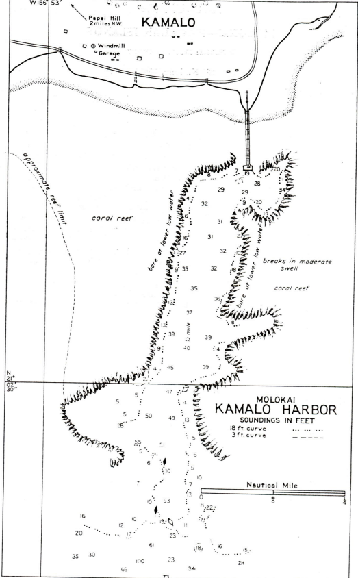
DESCRIPTION
Location: Restricted anchorage adjacent to the end of the pier.
Depths: 7 to 32 feet.
Tidal range: 2 feet.
Character of bottom: Gray mud.
Currents: Weak.
Shelter: This harbor is the only one along the south coast of Molokai that is considered safe during southwesterly storm. The swell is not felt within the harbor.
LANDING AND TAKE-OFF AREA
Location: Kamalo Harbor or open sea.
Area: Kamalo Harbor N./S., 1/2 mile; E./W., 130 – 250 yards.
Shelter: Fair, reefs only.
Obstructions: Coral reef on both sides of harbor, which can be easily seen by day. Buoys
FACILITIES
Provisions and water can be obtained in limited quantities.
Communications: Local steamer calls weekly.
GENERAL INFORMATION
Aspects: Kamalo Harbor is a pocket in the reef opening southward.
Landmarks: Papai Hill, 2 miles northwest of Kamalo, is 830 feet high and 5/3 mile inland. It is bare of trees and has slightly lighter color than the mountain slopes in the background.
Tender anchorage: The entrance depth is limited by a bar with a general depth of 14 feet, though it is possible to carry 19 feet into the harbor by passing midway between the entrance buoys. The wharf with a small shed has 19 feet at its outer face.
Importance: Emergency seaplane anchorage.