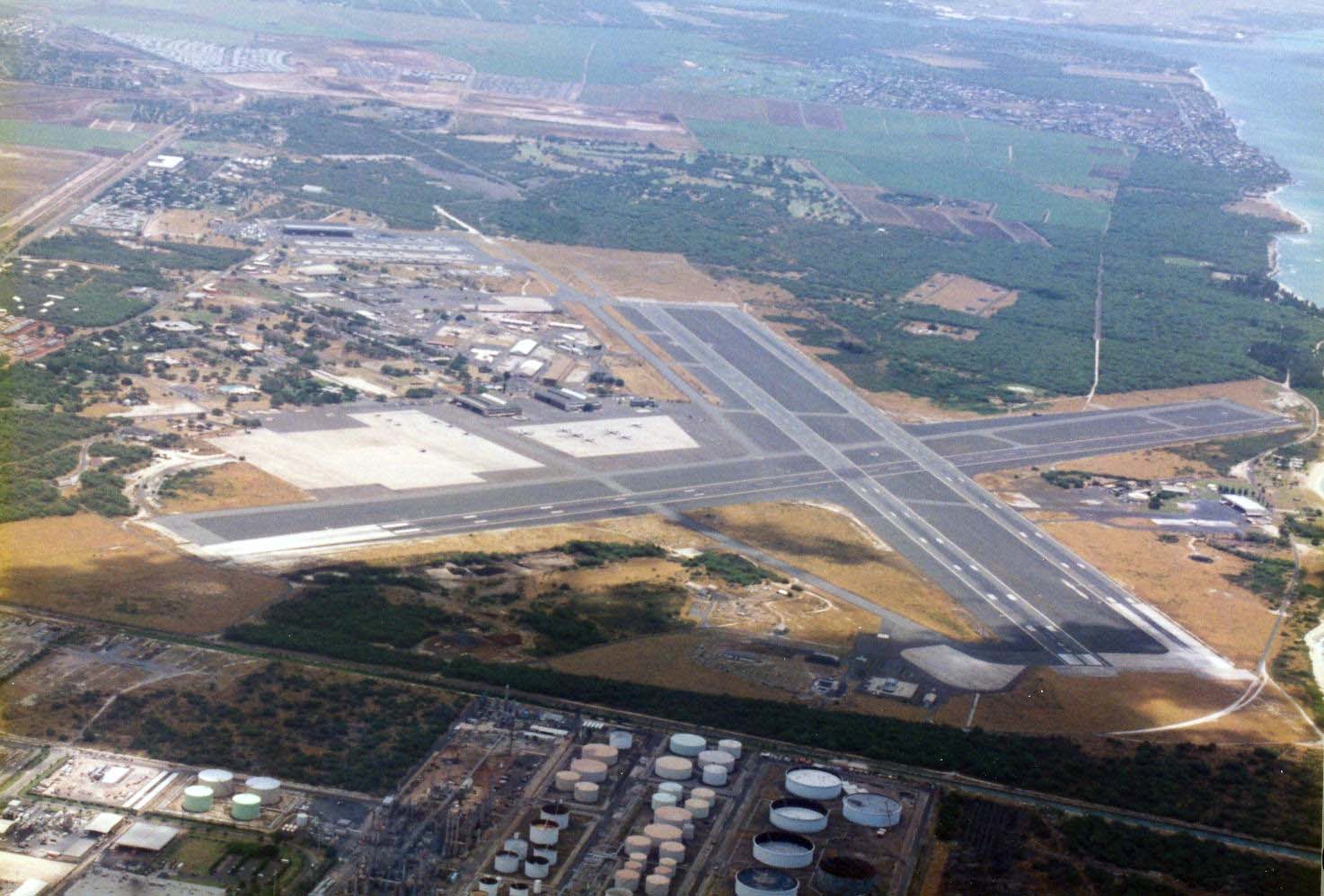
Kalaeloa Airport
 Barbers Point Naval Air Station was developed by the U.S. Navy in 1939 as a mooring station for airships. During World War II, both Ewa Marine Corps Air Station and Barbers Point NAS operated from the 3,709 acres. It was also the home of the Barbers Point Coast Guard Station. In 1996, the three runways handled about 46,000 air operations.
Kalaeloa (long point) is the original name for the southwestern tip of Oahu and was given to the airport by the Hawaii Department of Transportation and the Barbers Point Redevelopment Commission in the mid 1990s when the future of the former Barbers Point Naval Air Station was being debated.
Because the U.S. Navy had named the airfield after Commander John Rodgers who made the first attempt to fly from San Francisco to Hawaii in 1925, the Hawaii Department of Transportation chose to continue this tradition hence the designator JRF.
In anticipation of receiving the airport from the Navy, the Legislature through Act 116, SLH 1998, appropriated $1.5 million for design and construction of improvements, and $1.1 million for design and construction of perimeter fencing.
A Kalaeloa Airport Master Plan was published by the HDOT in November 1998. The master plan was completed with the assistance of the Redevelopment Commission to determine the combination of airport facilities that would best balance the needs of aviation users with other potential uses of the surplus land. The master plan recommended:
- Obtaining approximately 757 acres of land for an airport that included adequate land for an airfield with two parallel runways and a crosswind runway.
- Retaining Runway 4R-22L at a length of 8,000 feet.
- Shortening Runway 4L-22R to 4,500 feet.
- Retaining Runway 11-29, shortened to 6,000 feet to provide operational and land use compatibility benefits to the local community in maximizing takeoffs and landings over water. Providing a backup capability when Runway 4R-22L was closed for maintenance or other reasons.
- Preserving airfield capacity with parallel Runways 4L-22R and 4R-22L to meet forecast demand beyond the year 2020, which also reduces aircraft delay costs.
- Including navigational and landing aids and providing for an instrument approach capability and approach lighting system.
- Retaining approximately 115 acres for aviation and airport support facilities, including Hangar 110 and also two large aircraft parking aprons for future use as tie downs, hangars and lease lots.
- Including an air traffic control tower, aircraft rescue and firefighting facilities, weather reporting, HDOT administration building and maintenance areas, fuel storage, fencing and utilities.
- Utilizing existing airport access roads and vehicular parking facilities.
In addition, the Hawaii National Guard would have airfield access from its 160-acre reservation at the north end of the airport and the U.S. Coast Guard would continue to have airfield access from its 48-acre complex at the south end of the airport. Hangar 111 and about two acres of paved parking were transferred to the University of Hawaii, for aviation training.
The state accepted 757 acres of surplus land at Barbers Point Naval Air Station as Kalaeloa Airport on July 1, 1999 for use by general aviation aircraft to practice pilot training, formerly done at Ford Island and Honolulu International. A perimeter fence was constructed prior to the U.S. Navy turning over Kalaeloa Airport. The fence was necessary due to Federal Aviation Administration operational and security regulations. The fencing was completed prior to July 1, 1999, allowing for general aviation operations on the turnover date. Cost of the fencing was $1.1 million.
The airport has air traffic control functions from 0600 to 2200 daily but is available as an alternate 24/7/365 and has full daily fire fighting capability. Users are the U.S. Coast Guard, Hawaii Community College Flight Program, Hawaii National Guard and the general aviation community.
Governor’s Executive Order No. 3861 dated March 15, 2001 set aside 752.240 acres at the former Barbers Point Naval Air Station for Kalaeloa Airport.
Act 259, SLH 2001, appropriated $10 million for construction of improvements to include striping, airfield lighting and navigational aids. Act 200, SLH 2003, appropriated $500,000 for design and construction of facility improvements, including lease lots, aprons, runways, taxiways and aviation facilities. Act 160, SLH 2006, appropriated $5.3 million for design and construction of facility improvements; $2.26 million for construction of Hangar 110 renovations, and $3.9 million for utility system improvements. Act 213, SLH 2007, appropriated $6.5 for facility improvements
Recent major improvements to the Kalaeloa facilities include a new airfield lighting system, partial runway paving, emergency power systems, fire fighting and communication equipment. In 2006, the FAA installed an Instrument Landing System (ILS) on Runway 4R.
Kalaeloa Airport provides a launch site for Coast Guard Search and Rescue operations, a training base for general aviation, an emergency response platform, alternate landing site for airlines and the military, and extension of the capacity of HNL.
Four of the buildings on Kalaeloa Airport are eligible for the National Register of Historic Places because of their distinctive architecture. These are the Air Traffic Control Tower (Building 4), Hangars 110 and 111; and maintenance building (115) which was originally a torpedo assembly and maintenance facility.
Major touch and go training occurs at JRF. In 2009 there were 128,732 air operations.
Kalaeloa Airport will continue to be a link to Oahu’s World War II history while continuing to serve civilian and military aviation needs.
Related content
Governor’s Executive Orders Kalaeloa Airport
Kalaeloa Airport Air Traffic Statistics Kalaeloa Airport is used primarily by general aviation aircraft, flight schools and the military.