- News
- Aeronautic Laws
- Chronology/Events
- Aviation Pioneers
- Aviation Pioneers
- John Rodgers
- Emory Bronte
- Lt. Ben Cassiday
- Major Harold Clark
- Capt. John Curry
- Amelia Earhart
- Charles Fern
- Lt. Harold Geiger
- Arthur C. Goebel
- Dick Grace
- Tom Gunn
- Lt. Albert F. Hegenberger
- Martin Jensen
- Sir Charles Kingsford-Smith
- Lt. Lester Maitland
- J.C. “Bud” Mars
- Didier Masson
- Emil L. Melville
- Gus Schaefer & Burton Dryer
- Ernest Smith
- W. Ben Stoddard
- Charles Stoffer
- Elbert and Malcolm Tuttle
- Joseph Lawrence Van Tassell
- Clarence H. Walker
- Marguerite Gambo Woods
- Sen Yet Young
- Airfields & Airports
- Airfields & Airports
- Oahu
- Oahu
- John Rodgers Airport
- Honolulu International Airport
- Honolulu International Airport Air Traffic Statistics
- Ala Moana Airport
- Ala Wai Heliport
- Barber’s Point
- Bellows Field
- Dillingham (Kawaihapai) Airfield
- Ford Island/Luke Field
- Haleiwa Field
- Hickam Field/Air Force Base
- Kalaeloa Airport
- Kaneohe Naval Air Station
- Kipapa Field
- Naval Air Station 29 (Honolulu)
- Wheeler Field
- Hawaii
- Hawaii
- The Beginning of Aviation on the Big Island
- General Lyman Field/Hilo International Airport
- Ka Lae/Kau Airport
- Kamuela Airport (Bordelon Field)
- Kona Airport at Kailua
- Kona International Airport at Keahole
- Morse Field (South Cape Airport)
- Naalehu Airport
- Paauilo Airport
- Upolu Airport
- Waimea-Kohala Airport
- Hawaii Airport District Managers
- Kauai
- Lanai
- Maui
- Maui
- The Beginning of Aviation on Maui
- Hamoa Airport (Old Hana Airport)
- Hana Airport
- Kaanapali Airstrip
- Kahului Airport
- Kapalua Airport (West Maui)
- Kula Airport
- Lahaina Airport
- Maalaea Airport
- Naval Air Station 27 (Kahului)
- Naval Air Station 30 (Puunene)
- Maui Airport (Puunene)
- Maui District Airport Managers
- Molokai
- Seaplane Anchorage
- Seaplane Anchorages
- French Frigate Shoals Seaplane Anchorage
- Pearl Harbor – Fleet Air Base Seaplane Anchorage
- Kaneohe Bay Seaplane Anchorage
- Kaunakakai Harbor Seaplane Anchorage
- Kamalo Harbor Seaplane Anchorage
- Lahaina Roads Seaplane Anchorage
- Kahului Harbor Seaplane Anchorage
- Hana Bay Seaplane Anchorage
- Kaumalapau Harbor Seaplane Anchorage
- Hanapepe Bay Seaplane Anchorage
- Nawiliwili Bay Seaplane Anchorage
- Hanamaulu Bay Seaplane Anchorage
- Hanalei Bay Seaplane Anchorage
- Kealakekua Bay Seaplane Anchorage
- Kawaihae Bay Seaplane Anchorage
- Kailua Bay Seaplane Anchorage
- Hilo Bay Seaplane Anchorage
- French Frigate Shoals
- Ceded Lands
- Major Air Incidents
- Airliners
- Pioneer Airlines
- Pioneer Airlines
- Inter-Island Airways/Hawaiian Airlines
- Pan American Airways
- Aloha Airlines
- Andrew Flying Service
- British Overseas Airways Corp
- Canadian Pacific Air Lines
- Continental Airlines
- EVA Air
- Gambo Flying Service
- Japan Air Lines
- Northwest Orient Airlines
- Omni
- Philippine Airlines
- Qantas
- Teal
- Trans International Airlines
- United Air Lines
- World Airways
- World War II
- World War II
- December 7, 1941
- December 7, 1941
- A Handful of Pilots
- Hickam Field December 7, 1941
- Attack at Bellows Field
- Brief Summary of December 7, 1941
- Cloak of Darkness
- George J. Gabik Memories
- Enterprise Air Group Report on December 7, 1941
- First to Fight
- Hickam Report December 8, 1941
- Highlights of December 7, 1941
- Hot Reception at Pearl Harbor
- One Sunny Day on Niihau
- Pearl Harbor’s Deadly Dozen
- Report of Enemy Activity December 7, 1941
- Roosevelt’s Day of Infamy, My Day of Hell
- Summary of the Attack, December 7, 1941
- The Story of Joseph I. Muratsuchi
- The True Story of Pearl Harbor
- Those Aging Ghosts of Pearl Harbor
- Three Hours of Hell
- Eye Witness Accounts of Bombing of Hickam AFB
- World War II Photo Gallery
- Military Aviation on Oahu, 1944
- Corps of Engineers WW II Pacific Operations
- Interview with Lt. George S. Welch
- Aviation Photos
- Publications
- Publications
- HNL – First 80 Years
- HNL – 80th Anniversary Brochure
- 25th Anniversary John Rodgers Terminal 1987
- Territorial Aeronautical Commission
- DOT Annual Reports
- DOT Annual Reports
- 1962-1963 DOT Annual Report
- 1964 DOT Annual Report
- 1965 DOT Annual Report
- 1966 DOT Annual Report
- 1967 DOT Annual Report
- 1968 DOT Annual Report
- 1969 DOT Annual Report
- 1970 DOT Annual Report
- 1971 DOT Annual Report
- 1972 DOT Annual Report
- 1973 DOT Annual Report
- 1974 DOT Annual Report
- 1975 DOT Annual Report
- 1976 DOT Annual Report
- 1977 DOT Annual Report
- 1978 & 1979 DOT Annual Report
- 1980 DOT Annual Report
- 1981 DOT Annual Report
- 1982 DOT Annual Report
- 1983 DOT Annual Report
- 1984 DOT Annual Report
- 1985 DOT Annual Report
- 1986 DOT Annual Report
- 1987 DOT Annual Report
- 1985 DOT Annual Report
- 1986 DOT Annual Report
- 1987 DOT Annual Report
- 1991 DOT Annual Report
- 1992 DOT Annual Report
- 1993 DOT Annual Report
- 1994 DOT Annual Report
- 1995 DOT Annual Report
- 1996 DOT Annual Report
- 1997 DOTAnnual Report
- 1998 DOT Annual Report
- 1999 DOT Annual Report
- 2000 DOT Annual Report
- 2001 DOT Annual Report
- 2002 DOT Annual Report
- 2003 DOT Annual Report
- 2004 DOT Annual Report
- 2005 DOT Annual Report
- 2006 DOT Annual Report
- 2007 DOT Annual Report
- Territory of Hawaii Superintendent of Public Works Reports
- Territory of Hawaii Superintendent of Public Works Reports
- 1932 TH Public Works Report
- 1933 TH Public Works Report
- 1934 TH Public Works Report
- 1935 TH Public Works Report
- 1936 TH Public Works Report
- 1937 TH Public Works Report
- 1938 TH Public Works Report
- 1939 TH Public Works Report
- 1940 TH Public Works Report
- 1941 TH Public Works Report
- 1943 TH Public Works Report
- 1946 TH Public Works Report
- 1947 TH Public Works Report
- 1948 TH Public Works Report
- 1950 TH Public Works Report
- 1951 TH Public Works Report
- 1952 TH Public Works Report
- 1953 TH Public Works Report
- 1954 TH Public Works Report
- 1955 TH Public Works Report
- 1956 TH Public Works Report
- 1957 TH Public Works Report
- 1958 TH Public Works Report
- Hawaii Aeronautics Commission
- Hawaii Aeronautics Commission
- HAC Annual Reports
- HAC Annual Reports
- 1948 Hawaii Aeronautics Commission Report
- 1949 Hawaii Aeronautics Commission Report
- 1950 Hawaii Aeronautics Commission Report
- 1951 Hawaii Aeronautics Commission Report
- 1952 Hawaii Aeronautics Commission Report
- 1953 Hawaii Aeronautics Commission Report
- 1954 Hawaii Aeronautics Commission Report
- 1955 Hawaii Aeronautics Commission Report
- 1956 Hawaii Aeronautics Commission Report
- 1957 Hawaii Aeronautics Commission Report
- 1958 Hawaii Aeronautics Commission Report
- 1959 Hawaii Aeronautics Commission Report
- 1960 Hawaii Aeronautics Commission Report
- HAC Minutes
- HAC Minutes
- HAC Minutes 1947
- HAC Minutes 1947
- HAC 1947-06-20.pdf
- HAC 1947-07-07.pdf
- HAC 1947-07-16.pdf
- HAC 1947-07-28.pdf
- HAC 1947-08-04.pdf
- HAC 1947-08-11.pdf
- HAC 1947-08-25.pdf
- HAC 1947-08-26.pdf
- HAC 1947-08-28.pdf
- HAC 1947-09-04.pdf
- HAC 1947-09-09.pdf
- HAC 1947-09-23.pdf
- HAC 1947-10-06.pdf
- HAC 1947-10-20.pdf
- HAC 1947-11-03.pdf
- HAC 1947-11-05.pdf
- HAC 1947-11-07.pdf
- HAC 1947-11-24.pdf
- HAC 1947-12-01.pdf
- HAC 1947-12-15.pdf
- HAC 1947-12-29.pdf
- HAC Minutes 1948
- HAC Minutes 1948
- HAC 1948-01-05.pdf
- HAC 1948-01-10.pdf
- HAC 1948-01-16.pdf
- HAC 1948-02-02.pdf
- HAC 1948-02-06.pdf
- HAC 1948-02-16.pdf
- HAC 1948-02-26.pdf
- HAC 1948-03-01.pdf
- HAC 1948-03-12.pdf
- HAC 1948-03-22.pdf
- HAC 1948-04-05.pdf
- HAC 1948-04-14.pdf
- HAC 1948-05-03.pdf
- HAC 1948-05-25.pdf
- HAC 1948-05-28.pdf
- HAC 1948-06-07.pdf
- HAC 1948-06-21.pdf
- HAC 1948-07-06.pdf
- HAC 1948-08-02.pdf
- HAC 1948-09-03.pdf
- HAC 1948-09-13.pdf
- HAC 1948-10-04.pdf
- HAC 1948-10-15.pdf
- HAC 1948-11-01.pdf
- HAC 1948-11-08.pdf
- HAC 1948-12-06.pdf
- HAC 1948-12-13.pdf
- HAC Minutes 1949
- HAC Minutes 1949
- HAC 1949-01-03.pdf
- HAC 1949-01-17.pdf
- HAC 1949-01-24.pdf
- HAC 1949-02-01.pdf
- HAC 1949-02-07.pdf
- HAC 1949-02-10.pdf
- HAC 1949-02-14.pdf
- HAC 1949-02-21.pdf
- HAC 1949-03-07.pdf
- HAC 1949-04-04.pdf
- HAC 1949-04-25.pdf
- HAC 1949-05-02.pdf
- HAC 1949-05-03.pdf
- HAC 1949-06-06.pdf
- HAC 1949-06-22.pdf
- HAC 1949-07-09.pdf
- HAC 1949-08-01.pdf
- HAC 1949-08-11.pdf
- HAC 1949-09-19.pdf
- HAC 1949-10-17.pdf
- HAC 1949-11-21.pdf
- HAC 1949-12-12.pdf
- HAC Minutes 1950
- HAC Minutes 1950
- HAC 1950-01-07.pdf
- HAC 1950-02-07.pdf
- HAC 1950-02-19.pdf
- HAC 1950-02-28.pdf
- HAC 1950-03-20.pdf
- HAC 1950-04-17.pdf
- HAC 1950-05-09.pdf
- HAC 1950-05-15.pdf
- HAC 1950-05-23.pdf
- HAC 1950-06-01.pdf
- HAC 1950-06-26.pdf
- HAC 1950-07-10.pdf
- HAC 1950-07-24.pdf
- HAC 1950-08-28.pdf
- HAC 1950-09-25.pdf
- HAC 1950-10-23.pdf
- HAC 1950-11-11.pdf
- HAC 1950-11-27.pdf
- HAC 1950-12-28.pdf
- HAC Minutes 1951
- HAC Minutes 1951
- HAC 1951-01-22.pdf
- HAC 1951-01-29.pdf
- HAC 1951-02-08.pdf
- HAC 1951-02-19.pdf
- HAC 1951-03-05.pdf
- HAC 1951-03-19.pdf
- HAC 1951-04-23.pdf
- HAC 1951-05-07.pdf
- HAC 1951-05-28.pdf
- HAC 1951-06-05.pdf
- HAC 1951-06-25.pdf
- HAC 1951-07-23.pdf
- HAC 1951-08-27.pdf
- HAC 1951-09-24.pdf
- HAC 1951-10-22.pdf
- HAC 1951-11-01.pdf
- HAC 1951-11-13.pdf
- HAC 1951-11-26.pdf
- HAC 1951-12-17.pdf
- HAC Minutes 1952
- HAC Minutes 1955
- HAC Minutes 1956
- HAC Minutes 1956
- HAC 1956-01-21.pdf
- HAC 1956-02-25.pdf
- HAC 1956-03-24.pdf
- HAC 1956-04-28.pdf
- HAC 1956-05-26.pdf
- HAC 1956-06-15.pdf
- HAC 1956-07-28.pdf
- HAC 1956-08-31.pdf
- HAC 1956-09-13.pdf
- HAC 1956-09-29.pdf
- HAC 1956-10-10.pdf
- HAC 1956-10-27.pdf
- HAC 1956-11-13.pdf
- HAC 1956-11-13Spec.pdf
- HAC 1956-12-07.pdf
- HAC 1956-12-21.pdf
- HAC Minutes 1957
- Airport Zoning Board
- Airport Zoning Board
- AZB Minutes 1952-08-15
- AZB Minutes 1952-09-05
- AZB Minutes 1952-11-26
- AZB Minutes 1952-12-15
- AZB Minutes 1952-12-22
- AZB Minutes 1953-02-27
- AZB Minutes 1953-03-10
- AZB Minutes 1953-04-01
- AZB Minutes 1953-04-08
- AZB Minutes 1953-04-25
- AZB Minutes 1953-05-15
- AZB Minutes 1953-05-16
- AZB Minutes 1953-05-29
- AZB Minutes 1953-06-15
- AZB Minutes 1953-06-19
- AZB Minutes 1953-09-25
- AZB Minutes 1954-01-06
- AZB Minutes 1955-08-30
- AZB Minutes 1957-04-26
- AZB Minutes 1958-01-09
- AZB Minutes 1958-09-04
- AZB Minutes 1959-08-05
- AZB Minutes 1959-11-06
- Report to the Governor 1937
- Air Facilities Report 1975
- Honolulu International Airport Publications
- Honolulu International Airport Publications
- 1989 Economic Impact Report HNL
- 1998 Economic Impact Study
- 1990 Hawaii Airports Pacific Gateway to the US
- 1991 HNL International Terminal Complex
- 1990 Honolulu the Right Location With the Right Connections
- 1994 Interisland Terminal Press Kit
- HNL Gardens
- Reef Runway First in Design
- Reef Runway Project
- Thesis HNL Economics & Management
- A Brief History of Master Planning for HNL
- 1951 Airport Rules and Regulations
- FAA Historical Fact Book 1926-1963
- Kalaeloa Airport
- Naval Air Pilot 1936
- Statewide Air System Plan 1998
- Naval Air Station 29 (Honolulu)
- 1945 History of Barbers Point Naval Air Station
- Above the Pacific by Lieutenant Colonel William Joseph Horvat 1966
- Military Aviation
- Miscellaneous
- Miscellaneous
- Air Facilities Report 1975
- Air Handbook 1971
- Air Transportation in Hawaii CAA 1950
- Building the Navy’s Bases in World War II
- Airports at the Crossroads 1955
- Economic Impact Report HNL 1989
- Economic Impact Study 1998
- FAA History Fact Book
- Hawaii Airports Pacific Gateway 1990
- Hawaii State Airport System Plan 1976
- HNL International Terminal Complex 1990
- HNL New International Terminal Complex 1989
- Honolulu the Right Location With All the Connections
- Interisland Terminal Press Kit 1994
- Master Plan Honolulu International Airport 1951
- Kalaeloa Airport Master Plan
- NAS Honolulu Annual Reports
- Naval Air Pilot Pacific Islands 1935
- Oahu General Aviation Study 1973
- Reef Runway Project
- Report to the Governor 1937
- Statewide Airport System Plan 1998
- Related Links
Kealakekua Bay Seaplane Anchorage
Source: Naval Air Pilot, 1936. 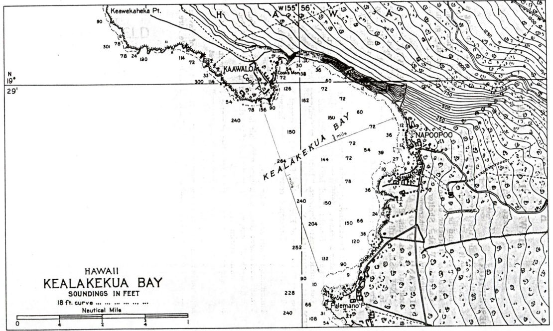
DESCRIPTION
Location: Within the bay adjacent to Napoopoo village. In choosing an anchorage it is well to remember that there is a sea breeze in the daytime, shifting to a land breeze at night. (Lat. 19*28′ N., long. 155*56′ W.)
Depths: 6 to 60 feet.
Tidal range: 1.4 feet.
Character of bottom: Coral and sand; fair holding ground.
Currents: Weak.
Shelter: Small lee; good anchorage and shelter only during the northeast trades for about six planes.
LANDING AND TAKE-OFF AREA
Location: Kealakekua Bay.
Area: Indents coast ENE./WSW. 3/4 miles; NNW./SSE., 1 mile.
Shelter: Small lee. Long take-offs must be made in open sea.
Obstructions: Frequently a heavy swell exists in the bay. Precipitous cliff between 400 and 600 feet high and about 1/2 mile long on northeast side.
FACILITIES
Provisions can be obtained in limited quantities at the village Napoopoo. Fresh water is scarce. Ordinary gasoline and some ship chandlery may be obtained.
Beach: Sand beach at north and south end village.
Communications: Telephone. Local steamer calls regular.
GENERAL INFORMATION
Aspects: The shore of Kealakekua Bay is low, except on the northeast side. The village of Napoopoo consists of a few houses scattered among the coconut trees.
Landmarks: White church with spire.
Tender anchorage: Good anchorage with fair holding ground can be found in 12 to 18 fathoms, with south end of the cliff bearing 55 degrees, and Cooks Monument bearing 314 degrees.
Boat landing: The landing, with about 4 feet of water, is in the middle of the village alongside of a low shed; during heavy swell it is best to land on the sand beach at the north end of the village.
Importance: Reported to be the best anchorage on the west coast of Hawaii. Forced landings, when quick repairs can be made, could be made here in moderate weather.