Kahului Harbor Seaplane Anchorage
Source: Naval Air Pilot, 1936.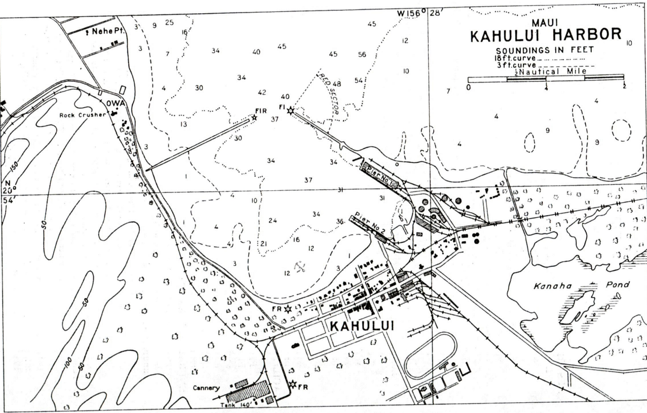
DESCRIPTION
Location: Southern part of harbor adjacent to the town. Heavy weather anchorage between Piers 1 and 2.
Depths: 6 to 36 feet.
Tidal range: 1.6 feet.
Character of bottom: Coral and mud.
Currents: Weak.
Shelter: Mooring facilities are good for maximum number of 9 VO-type seaplanes. The chart indicated that about 19 planes could be moored but the restricted operating area would not permit operating more than 9. Moored planes would probably weather anything less than a gale from any direction but would probably weather anything less than a gale from any directions but would be subjected to heavy swells if the gale came from the northwest. It is believed that by laying heavy weather moorings in the lee of the piers, 6 planes could ride out a gale in perfect safety. In the opinion of the local harbor master the breakwater would probably not afford sufficient protections under these wind conditions.
LANDING AND TAKE-OFF AREA
Location: Kahului Harbor and approaches.
Area: Restricted. Approaches for landings must be made over land for all northerly winds. Take-offs must be made toward the entrance between the breakwaters which under certain conditions of wind and sea would be impossible. A heavily loaded plane would run through breakwaters which under certain conditions of wind and sea would be impossible. A heavily loaded plane would run through breakwater entrance when taking off in a light wind.
Shelter: Safe landings can be made under any reasonable conditions of wind directions or force. Take-offs are practicable so long as sea conditions outside harbor entrance are reasonably good. For southerly winds take-offs must be made in the open sea and toward the breakwater entrance.
Obstructions: Harbor buoys. Shoals to west.
FACILITIES
Aviation gasoline and oil obtained through shipments made from Honolulu. Planes are serviced by boats or from tender; winds stronger than force 4 blowing for periods of 2 or more hours makes servicing of planes hazardous and perhaps impossible. Machine shops are available where minor repairs could be made. Small marine railway.
Beach: South shore of harbor almost entirely free from rock and coral; about 100 yards in length.
Communications: Telegraph, telephone, and radiotelephone service.
GENERAL INFORMATION
Aspects: The shores of the bay are low and sandy; much higher ground is to be found on both sides of the harbor at a distance of 2 or 3 miles.
Landmarks: Aluminum-colored water tank of the pineapple cannery 1/2 mile southwest of Kahului. Large gray building 400 yards northwestward of the inshore end of the west breakwater. Power station 180-foor concrete stack 1 mile southeastward. Wailuku mill stack about 1.25 miles west. Puunene mill black twin stacks, 1.75 miles southeastward. Name “KAHULUI” on building.
Tender anchorage: Large vessels do not ordinarily anchor within the breakwater because of the restricted swinging room. The controlling depth of the harbor is 31 feet and the general depths are 33 feet. The entrance between the breakwaters is 240 yards wide. Two modern wharves with large warehouse, extensive cargo-handling equipment, and rail connection. Pier No. 1 has length of about 1000 feet, a depth of 31 feet along side, and is used by large ocean steamers. Pier No. 2 is about 850 feet long, has a depth of 29 to 33 feet along its northeast sire. Interisland steamers dock at this pier.
Importance: Kahului Harbor is the most important harbor in the island of Maui, as well as the only one with protection from all weather.
Meteorological conditions: Prevailing winds, northeast trades, which shift to a southerly direction frequently with a little or no warning. Strong northerly, and especially northwesterly winds blowing for any length of time cause a heavy swell which is felt in the harbor.