French Frigate Shoals Seaplane Anchorage
Source: Naval Air Pilot, 1936.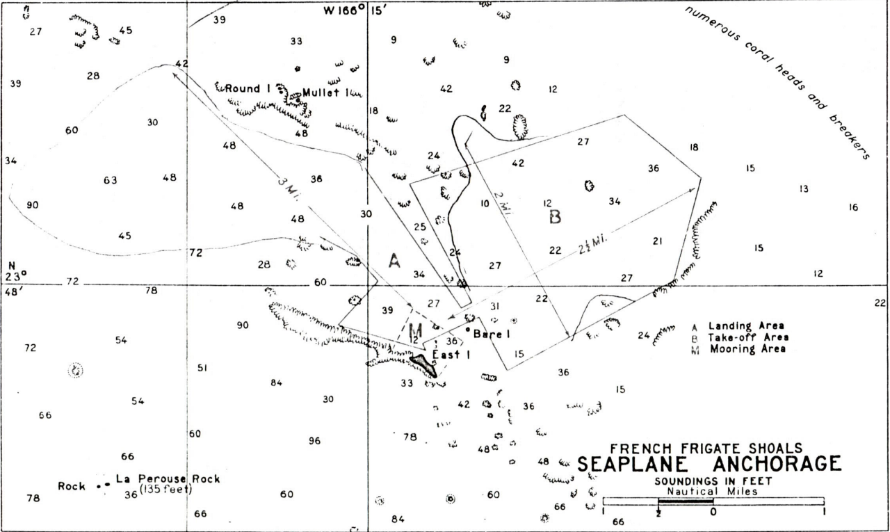
DESCRIPTION
Location: Anchorage and mooring area close in and northward of East Island.
Depths: 9 to 30 feet.
Tidal range: 2 feet.
Character of bottom: Coral and sand.
Currents: Westerly.
Shelter: During April 1933 when 30 VP-type seaplanes were moored here the wind reached 35 miles per hour at times and veered from northeast to southeast but the anchorage was well protected and planes rode very satisfactorily to the moorings. It is believed that his anchorage would be sufficiently protected from a wind and sea from the southwest.
LANDING AND TAKE-OFF AREA
Location: North and northeast of East Island.
Area: (A) Landing area, NW./SE. 3 miles, (B) Take-off area, NE./SW. 2.5 miles; NNW./SSE. 2miles.
Shelter: Surrounding reef breaks up the seas coming from the open, and small sand islets and shoal spots within the lagoon are such that rough seas do not make up inside the reef.
Obstructions: Numerous coral heads.
FACILITIES
None. Tenders would be required for servicing planes. Brackish water has been found by digging wells about 8 feet deep on the sand islets back from the beach.
GENERAL INFORMATION
Aspects: French Frigate Shoals is a crescent-shaped atoll with a number of small, bare, sand islets. It is 17 miles long in general northwest-southeast direction, and 12 miles wide at southern end. East Island is a low sand islet 600 yards long and 100 yards wide. It is about 10 feet high, has a scattering of low weeds, and is the nesting place of sea birds and turtles.
Landmarks: First sighted, French Frigate Shoals appears as a line of breakers on the horizon. La Perouse Pinnacle, 135 feet high, is a volcanic rock islet about 600 yards long and 20 yards wide, and from a distance resembles a square-rigged sailing ship.
Tender anchorage: The large vessel anchorage with good holding ground, is between 1 and 4 miles south of La Perouse Pinnacle and between 166*15′ and 166*20′ meridians of longitude in 10 to 15 fathoms of water. There is no anchorage for large vessels protected from all weather.
The small vessel anchorage with a good holding ground is 3/4 miles southwestward of East Island in 14 fathoms of water, the center of East Island bearing 28 degrees. This anchorage is protected from northeast and easterly winds but is exposed to westward.
An excellent Ice may be obtained anywhere about the shoal in accordance with prevailing wind and weather.
Importance: Commander base force in 1933 states ” It appears that the area cannot be considered a satisfactory potential base except in a very limited sense.” The district intelligence officer of the fourteenth naval district, in report on the military aspects of the Leeward Islands of Hawaii and Johnston and Wake Islands in 1923, states “It is believed that the atoll offers the best opportunities of any of the group under consideration for an advance base, on which could be centered the activities of an air force, or fleet of small craft, as well as a good anchorage for larger vessels.
Meteorological conditions: The northeast trades prevail throughout the year, but westerly blows can be expected during the winter months.