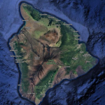
Hawaii
AIRPORTS & AIRFIELDS
The Beginning of Aviation on the Big Island
The history of aviation on the Big Island dates back to June 10, 1911 when Clarence H. Walker came to Hilo for an exhibition flight in his Curtiss Biplane. There were no airports on the island, so Hoolulu Park was selected for the runway.
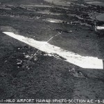
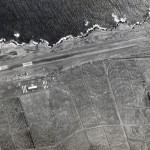
General Lyman Field/Hilo International Airport
On February 25, 1925, Speaker of the House Norman K. Lyman of Hilo introduced a resolution requesting the governor to set aside 50 acres of land at Waiakea for a landing field. This was amended to 100 acres the following day by the Aviation Committee.

On October 15, 1926 Governor’s Executive Order No. 258 set aside 517 acres in Ka Lae, Kamoao, Kau, Hawaii for a military reservation to be used as a site for an aeroplane landing field for the U.S. Air Service to be under the control and management of the War Department.
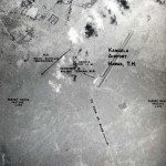
Kamuela Airport (Bordelon Field)
During World War II, the 3rd Marine Corps built a small airstrip near Kamuela, Hawaii, consisting of a graded and oiled airstrip 3,000-feet long on land belonging to Parker Ranch.
The first airplane landing in Kailua-Kona was on August 21, 1935 by Hilo aviator Alfred W. Smith. Smith landed his Aeronca single-seated monoplane on a cleared area about a mile north of Kailua, the first airplane ground landing ever made in Kona.
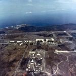
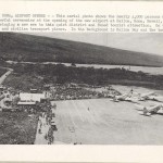
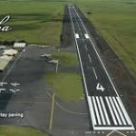
Kona International Airport at Keahole
Kona International Airport at Keahole is located on the western coast of the Island of Hawaii, approximately 10 miles from the town of Kailua Kona.
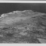
Morse Field (South Cape Airport)
On February 6, 1940, Governor’s Executive Order No. 869 set aside 182.38 acres of land for an addition to the Kalae Military Reservation as previously set aside by GEO No. 258, which was covered by Presidential EO No. 4635.
The Superintendent of the Territorial Department of Public Works proposed construction of a Class I Airport at Naalehu, Hawaii in 1947. The airport was proposed as a unit of the Territorial Airport System primarily because of the tourist interest in the area and also to encourage private flying.
In 1947 the Superintendent of the Territorial Department of Public Works proposed building a Class I airport at Paauilo on the northeast coast of the Big Island, halfway between Upolu Airport and Hilo Airport.
Upolu Airport is located three miles northwest of the town of Hawi on the northern tip of the coast of the Big Island of Hawaii.
Waimea-Kohala Airport is located south of Kamuela Town at an elevation of 2,671 feet in the northern portion of the Big Island of Hawaii.
SEAPLANE ANCHORAGES
| Hilo Bay | The westerly shore of Hilo Bay is bluff, while the southerly and easterly shores are low. Limited quantities of aviation gasoline and oil available, by making advance arrangements with the harbor authorities through the commandant; 14th Naval District machine shops are available where minor repairs could be made. No drydocks or large marine railways. |
| Kailua Bay | Kailua Bay is a small indentation in the coast at southerly end of a flat plain. Provision and water can be obtained in limited quantities. Ordinary gasoline and some ship chandlery may be obtained. Standard Oil branch warehouse is located here. |
| Kawaihae Bay | The shore Kawaihae Bay is rocky with stretches of sand beach and has thick growth of algaroba trees. Provisions and water can be obtained in limited quantities. |
| Kealakekua Bay | The shore of Kealakekua Bay is low, except on the northeast side. The village of Napoopoo consists of a few houses scattered among the coconut trees. Provisions can be obtained in limited quantities at the village Napoopoo. Fresh water is scarce. Ordinary gasoline and some ship chandlery may be obtained. |
AIR TRAFFIC STATISTICS
Hilo International Airport Air Traffic Statistics
Kona International Airport at Keahole Air Traffic Statistics
South Cape Airport (Morse Field) Air Traffic Statistics
GOVERNOR’S EXECUTIVE ORDERS
Governor’s Executive Orders Hilo Airport
Governor’s Executive Orders Kalae (Morse Field)
Governor’s Executive Orders Kailua (Kona) Airport
Governor’s Executive Orders Kamuela/ Waimea-Kohala Airport