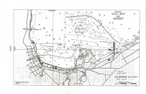
Hilo Bay Seaplane Anchorage
 Source: Naval Air Pilot, 1936.
DESCRIPTION
Location: The Hilo Bay Seaplane Anchorage is located within the harbor under the lee of the breakwater. (Lat. 19o44’30” N., long. 155o04’00” W.)
Depths: 6 to 46 feet.
Tidal range: 1.6 feet.
Character of bottom: Hard.
Currents: Weak.
Shelter: Protected anchorage for about 50 VP-type seaplanes is available under all conditions of wind and weather.
Importance: Good advance base for the operation of about 50 VP-type seaplanes. Hilo is the second in commercial importance and population of the cities of the Hawaiian Islands.
LANDING & TAKE OFF AREA
Location: Hilo Bay.
Area: NE./SW., 1 mile; E./W., 1 mile.
Shelter: There is sufficient room under normal full load conditions for both day and night operations. Take off under overload conditions for long distance flights is questionable. Outer bay is exposed to the northeast trades.
Obstructions: Harbor buoys. Ground swells in entrance to harbor. No high hills in the immediate vicinity of the harbor which interfere with landing and take-off. Large fleet of fishing sampans operates in the outer bay; the movements of these boats are uncertain.
FACILITIES
Limited quantities of aviation gasoline and oil available, by ;making advance arrangements with the harbor authorities through the commandant; 14th Naval District machine shops are available where minor repairs could be made. No drydocks or large marine railways.
Beach: No seaplane beach available. Plans must be serviced by boats or from a tender.
Communications: Radio station, call letters KLN. United States Navy radio station, call letters, NPH inoperative.
GENERAL INFORMATION
Aspect: The westerly shore of Hilo Bay is bluff, while the southerly and easterly shores are low.
Landmarks: Sugar mill at Alealea Point, painted gray and has one large concrete stack; number of electric lights when in operation at night. High concrete stack of the Hilo electric plant at Waiakea. Two radio towers 500 yards east of the wharves. Green (Halai) Hill, 347 feet high 1 mile southwest of Hilo is the highest point in the vicinity.
Tender anchorage: Anchorage can be had anywhere under the lee of the breakwater in up to 7 fathoms. Good anchorage in from 4 to 6 fathoms with good holding ground is from 1/4 to 3/4 mile westward from Kaulainaiwi Island. For deep-draft vessels the usual anchorage is 3/8 mile east of Alealea Point, in 7 to 8 fathoms. In 1933 the channel leading to the wharves in Kuhio Bay had a depth of 36 feet. The two large well-equipped wharves have a depths of 27 to 36 feet alongside.
Meteorological Conditions: Practically any schedule of operations can be carried out between the first of April and the middle of November. Between the middle of November and the end of March, frequent interruptions or delays in aircraft operation schedules may be expected; these delays normally should not last more than 2 or 3 days.
Meteorological table
| Weather element | Jan. | Feb. | Mar. | Apr. | May | June | July | Aug. | Sept. | Oct. | Nov. | Dec. | Annual |
|---|---|---|---|---|---|---|---|---|---|---|---|---|---|
| TEMPERATURE (F) | |||||||||||||
| Mean Monthly | 69.7 | 69.2 | 69.8 | 70.6 | 72.2 | 73 | 73.9 | 74.8 | 74.4 | 74 | 72.6 | 70.8 | 72.1 |
| Mean Max. | 77.4 | 77.2 | 77 | 77.6 | 79.6 | 80.1 | 80.9 | 82.2 | 82.1 | 81.5 | 79.9 | 78.4 | 49.5 |
| Mean Min. | 62.1 | 61.6 | 62.6 | 63.7 | 64.8 | 65.9 | 66.8 | 67.5 | 66.7 | 66.4 | 65.2 | 63.3 | 64.7 |
| Highest recorded | 88 | 88 | 88 | 89 | 89 | 80 | 90 | 91 | 89 | 88 | 90 | 89 | 91 |
| Lowest Recorded | 54 | 53 | 56 | 59 | 51 | 60 | 61 | 60 | 60 | 60 | 59 | 53 | 51 |
| PRECIPITATION | |||||||||||||
| Monthly amount (inch) | 9.93 | 11.47 | 15.14 | 13.44 | 10.08 | 8.11 | 10.77 | 12.32 | 10.81 | 11.05 | 14.64 | 11.67 | 139.43 |
| Number of days with 0.01 inch or more | 18 | 16 | 23 | 26 | 24 | 24 | 27 | 25 | 24 | 24 | 24 | 24 | 279 |
| WINDS | |||||||||||||
| Prevailing directions | N. | NE. | NE. | NE. | E. | NE. | N. | NE. | NE. | NE. | NE. | N. | NE. |