Lahaina Roads Seaplane Anchorage
Source: Naval Air Pilot, 1936. 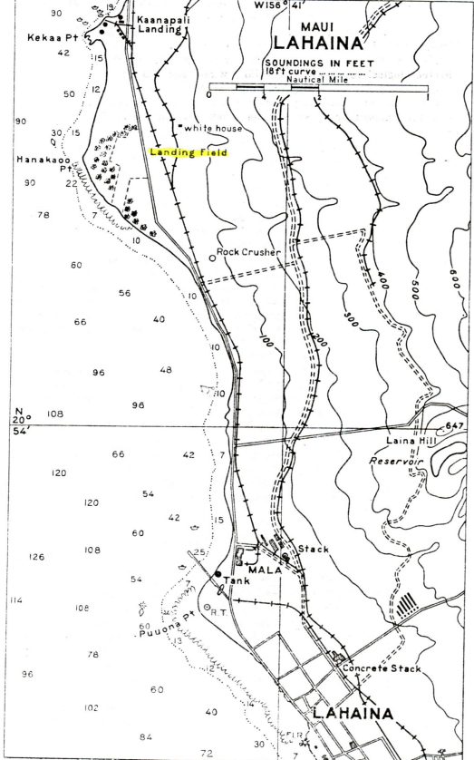
DESCRIPTION
Location: Lahaina Roads approximately 7/8 miles north of Mala Wharf, 200 to 300 yards offshore.
Depths: 6 to 36 feet.
Tidal range: 1.7 feet.
Character of bottom: Sand and coral.
Currents: Sets northward on the ebb and southward on flood; the northerly current is the stronger and may reach a velocity of 2 knots about 1 hour before low water. Slight southerly current of short duration may be expected 1 to 2 hours before high water.
Shelter: Good lee is afforded under almost all wind conditions, excepting storms or winds of high velocity. Seaplanes can operate from tenders and be afforded safe anchorage during average weather conditions.
Remarks: Good anchorage for a large number of planes.
LANDING AND TAKE-OFF AREA
Location: Lahaina Roads.
Area: Unlimited. Landings and take-offs can be made in any directions.
Shelter: Large open roadstead between the islands of Maui and Lanai generally calm even though strong trades are blowing; it is exposed to south and southwesterly weather.
Obstructions: Seaplanes should not attempt to taxi alongside or fuel from dock; due to heavy surge. Reinforcement rods project several feet at end of Mala Dock.
FACILITIES
Provisions, water, and ordinary gasoline may be obtained at Lahaina is limited quantities. There are tow or three small hotels at Lahaina.
Beach: Sandy beach along shore.
Communications: Local steamers.
GENERAL INFORMATION
Aspects: The cost consist of a low sandy beach with fringe of coconut and algebra trees back of which the cane fields extend inland for about 2 miles. Between Lahaina and Mala the highway skirts the shore, and the automobile lights along the road are usually the only lights visible. Lahaina village is situated among the trees near the beach.
Landmarks: Most prominent feature in the vicinity of Lahaina is the high white, concrete stack of a mill located 3/8 mile north-northeastward of the wharf at Lahaina. Close to the inshore end Mala Wharf is silver colored oil tank, and a warehouse with the name “LAHAINA” in large letters on its roof. A large pineapple cannery is situated near the shore, about 300 yards northeastward of the wharf. Lahaina Hill 1.25 miles northeastward of Mala Wharf is a prominent cone 647 feet high, the lower slopes of which are covered with cane. A gray-colored rock crusher, 1.5 miles north of mala and close to the shore.
Tender anchorage: In approaching Lahaina vessels should keep about 1 mile offshore until the wharf or light bears 56 degrees and then head in on this course until near Lahaina buoy; anchor in 10 to 15 fathoms. At Mala anchorage can be had anywhere in the bay north of the wharf, 5/8 mile off shore, in about 12 fathoms, sandy bottom. Passenger steamers usually anchor off the wharf. There is a small wharf at Lahaina with 3 feet of water along side. At Mala there is a modern concrete wharf 960 feet long with depth of 32 feet at the end. The wharf has a small warehouse and derrick.
Boat landing: Passenger and freight for Lahaina are landed at the Mala Wharf.
Importance: Fleet seaplane operating base. Considered a good seaplane base for extended operations throughout all seasons of the year.