Nawiliwili Bay Seaplane Anchorage
Source: Naval Air Pilot, 1936.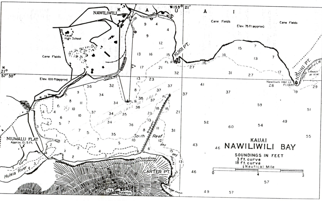
DESCRIPTION
Location: Nawiliwili Harbor, adjacent to the north shore. (Lat. 21*57′ N., 159*21′ W.).
Depths: 6 to 37 feet.
Tidal range: 1.2 feet.
Character of bottom: Sand and coral.
Currents: Weak.
Shelter: Good under any wind conditions for about 9 VP-type seaplanes.
LANDING AND TAKE-OFF AREA
Location: Nawiliwili Harbor.
Area: Less than a mile in any directions.
Shelter: Landing conditions for patrol planes, inside breakwater, are satisfactory and it is believed a safe landing can be made with wind from any directions. Take-off conditions are generally unsatisfactory due to the short run available and the limited arc through which a plane can be headed for a take-off.
With a strong trade wind from any direction between 0 degrees and 90 degrees, and a velocity of 20 knots or above, a fully loaded patrol plane can make a satisfactory take-off. With light winds, and blowing from directions other than those mentioned above, take-off conditions become comparatively unsatisfactory to a point where it becomes dangerous to attempt a take-off. It has been reported that during January and February with a trade wind blowing, the wind in the harbor was generally in a reverse direction until about 1000 each day unless the trade wind was exceptionally strong. Tis condition would prohibit operation of planes early in the day with heavy loads.
Light winds from southwest to west require down wind take-off; fully loaded planes would probably be unable to get off. With strong wind from this direction, the take-off is hazardous on account of hills.
Obstructions: Rocky bluff along shore. Harbor Buoys.
FACILITIES
Aviation gasoline and oil are not commercially available. Provisions are available to the extent required by any patrol plane detachment that could be accommodated in this harbor. No repair facilities available locally. Beach suitable for hauling out seaplanes.
Communications: Telephone. Local steamers.
GENERAL INFORMATION
Aspects: The shore of the bay consists of rocky bluffs except at the mouth of the Huleia River and in the northerly part near Nawiliwili village.
Landmarks: The bay may be easily recognized by the marked contrast between the prominent high jagged mountainous coast south of the entrance to the harbor and the low land in the vicinity of the Huleia River. Haupu Peak, 2280 feet high.
Tender anchorage: Ship drawing 28 feet of water can moor alongside the 900-foot wharf. Vessels in the lee of the breakwater may have to leave the inside anchorage on steamer days to clear the channel to the wharf and go outside, where there is a partially sheltered anchorage between Ninini and Kukii Points.
Importance: Nawiliwili Bay affords the only sheltered harbor on Kauai Island.
Recommendations: Commander aircraft base force in February 1934 reports that this base is not considered to be desirable one from which to operate patrol planes in war. Fully loaded planes can take-off under favorable conditions. However, the wind tends to be the light and variable in the early morning and occasionally is adverse later in the day. Under these conditions it is very likely that planes based here would be unable to carry out their missions through inability to get off.
Meteorological conditions: Local conditions, due to the influence of the surrounding mountains, wind conditions within the bay are not always indicative of conditions outside. Flying conditions outside may be excellent while conditions for landing and take-off are unfavorable because of wind direction.
Meteorological table
| Weather element | Jan. | Feb. | Mar. | Apr. | May | June | July | Aug. | Sept. | Oct. | Nov. | Dec. | Annual |
|---|---|---|---|---|---|---|---|---|---|---|---|---|---|
| TEMPERATURE (F) | |||||||||||||
| Mean Monthly | 68.2 | 68 | 69 | 70.7 | 72.7 | 74.9 | 76. | 76.5 | 76.3 | 74.6 | 72.3 | 70.3 | 72.5 |
| Mean Max. | 76.5 | 76.5 | 76.7 | 76.8 | 77.9 | 81.7 | 83 | 83.3 | 83.5 | 82.1 | 79.8 | 77.7 | 79.9 |
| Mean Min. | 59.9 | 59.3 | 61.3 | 63.5 | 65.6 | 68.1 | 68.9 | 69.6 | 69.2 | 67.2 | 64.8 | 62.8 | 65 |
| Highest recorded | 84 | 84 | 84 | 84 | 87 | 88 | 91 | 88 | 88 | 89 | 86 | 84 | 91 |
| Lowest Recorded | 47 | 47 | 48 | 51 | 54 | 62 | 59 | 58 | 62 | 57 | 51 | 50 | 47 |
| PRECIPITATION | |||||||||||||
| Monthly amount (inch) | 6.72 | 3.77 | 7.66 | 3.85 | 3.70 | 2.80 | 8.73 | 3.41 | 5.17 | 3.64 | 5.28 | 6.38 | 55.11 |
| Number of days with 0.01 inch or more | 19 | 16 | 18 | 18 | 19 | 21 | 22 | 22 | 22 | 22 | 21 | 22 | 242 |
| WINDS | |||||||||||||
| Prevailing directions | NE. | NE. | NE. | NE. | NE. | NE. | NE. | E. | NE. | NE. | NE. | NE. | NE. |