Kauai
AIRPORTS & AIRFIELDS
In 1947 the Territorial Superintendent of Public Works proposed building a Class I Airport at Hanalei, Kauai. The airport was proposed primarily for personal flying and for accommodation of small charter planes from Honolulu.

Governor’s Executive Order No. 245 dated May 22, 1926 set aside 65 acres of land at Puolo Point, Hanapepe, Kona, Kauai for a military reservation to be used as an Aeroplane Landing Field for the U.S. Air Service under the control and management of the War Department.
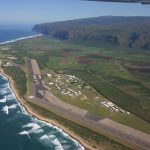
Lihue Airport is located 1.5 miles east of Lihue town on the east coast of the island of Kauai.
Mana Airport/Barking Sands Airport
Mana Airport was established in 1928 by the Territorial Legislature at a site in Mana, known as Barking Sands. In 1940, the land was set aside for the Mana Airport Military Reservation. During World War II and until 1950, Barking Sands was the primary commercial passenger airport on the island of Kauai until Lihue Airport opened.
In the early 1920s the U.S. Signal Corps and U.S. Army Air Corps used a portion of land near Port Allen as a landing strip (Burns Field). A Signal Corps reservation adjoining the airstrip housed personnel operating a communication station on the airfield.
Princeville Airport opened in 1977 as a quasi-public general aviation airport. Two commuter airlines served the airport with frequent daily flights.
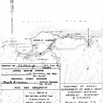
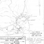
Governor’s Executive Order No. 2294 dated October 3, 1966 set aside 2.814 acres for a heliport and accessory purposes in Waimea, Kauai under the control and management of the Hawaii Department of Transportation.
Governor’s Executive Order No. 259 dated October 15, 1926, set aside a 116.25 acre military reservation in Wailua, Puna, Kauai, as a site for an aeroplane landing field for the U.S. Air Service to be under the control and management of the War Department.
SEAPLANE ANCHORAGES
| Kilauea Point | Lat 22*00′ N., 159*25′ W. It can only afford emergency anchorage in good weathers. |
| Waimea Bay | Lat 21*57′ N., 159*40′ W. An open bright affording excellent emergency anchorage during ordinary weather. It has limited facilities such as provisions, wharf, no repairs, and telephone. The beach are sandy and it’s not practical to use the Waimea River. |
| Hanalei Bay | Hanalei Bay 1 mile wide and indents the coast about the same distance. Along the sandy beach at the head of the bay are clumps of ironwood and coconut trees and a few houses. The village consists of a scattering of houses around the shores of the bay and along the highway close to the head of the bay. Three miles inland the mountains attain height of over 4000 feet. |
| Hanamaulu Bay | Hanamaulu Bay is 1/4 mile wide and indents the coast 1/2 mile. The shores are low rocky bluffs about 40 feet high except for the white sand beach at the head of the bay. |
| Nawiliwili Bay | The shore of the bay consists of rocky bluffs except at the mouth of the Huleia River and in the northerly part near Nawiliwili village. |
| Hanapepe Bay | The shores of Hanapepe Bay are low rocky bluffs except at its head. Provisions can be obtained on several day’s notice. No repair facilities. Numerous lighters and towing launches. |
AIR TRAFFIC STATISTICS
Lihue Airport Air Traffic Statistics
Barking Sands Airport Air Traffic Statistics
GOVERNOR’S EXECUTIVE ORDERS
Governor’s Executive Orders Hanapepe Airport
Governor’s Executive Orders Mana Airport
Governor’s Executive Orders Port Allen Airport